The Ottawa River

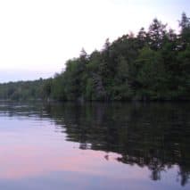
Imagine you are deep in the wilds of Quebec, following a tiny stream just outside La Vérendrye Wildlife Refuge. The stream grows larger, flowing through lakes and reservoirs on its way into Lake Temiskaming. Now a fast-moving river, it takes you past rocks and trees, then cottages and marinas. On one side is the province of Quebec, and on the other side is Ontario. As you pass Pembroke, you come to “Rocher Fendu” (split rock), a 12-kilometre stretch of wild whitewater. There you’ll find daring canoeists, kayakers, and rafters from around the world trying their luck in the rapids. At Arnprior, you pass Gillies Grove old growth forest, home to the tallest White Pine in Ontario – 50 metres tall!
Continuing down the river past the Chaudière Falls, the towers of Ottawa’s Parliament Buildings come into view. Pleasure boats and tourist cruise ships fill the river in the summer months. Past Hawkesbury, you move back into Quebec on your way to Montreal, where the Ottawa River meets the St. Lawrence.
You’ve travelled over 1200 kilometres on what the Algonquin First Nations, who lived along its banks, called Kichi Sibi – the great river. By 1650, smallpox and conflicts with the Iroquois had decimated the Algonquin population. The Ottawa First Nations, their allies to the west, took over the trading route along the river; the river became known as the “rivière des Outaouais” – the Ottawa River.
The watershed of the Kichi Zībī, known in English as the Ottawa River, is located on the unceded, ancestral territories of the Anishinābeg Algonquin Nation. The people of the Anishinābeg Algonquin Nation are the traditional and ongoing stewards of these lands and waters.
Ottawa Riverkeeper recognizes the legacy of colonialism that continues to have profound impacts on the rights of Algonquin people and their lands, and that there is urgent need for meaningful actions that truly confront this legacy.
 General Watershed Facts
Curious to learn more about the watershed? Find fast facts about the river here.
Flora and Fauna
Read up on the different plants and animals you can find in the watershed.

Map Gallery
Travel through the watershed from the comfort of your home. We have interactive maps detailing everything from points of interest along the river to sewage outlets in the National Capital Region.
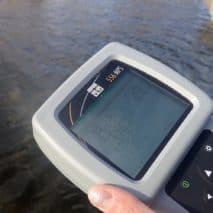 Water Quality and Quantity
Learn about the water quality in the river, including how, when, and where the water is tested.