Change in Land Use

Project main page || Data || Relationships || Further resources
Introduction:
There are many different ways that land is used within the Ottawa River watershed, from the urban sprawl of Ottawa-Gatineau, to the extensive farmland that frames the northern area of Lake Temiskaming, to the forests and wetland around Lac des Outaouais – the source for the Ottawa River – and everything in between. Land use and how it changes over time, particularly in terms of the extent of natural area, have profound effects on waterways.
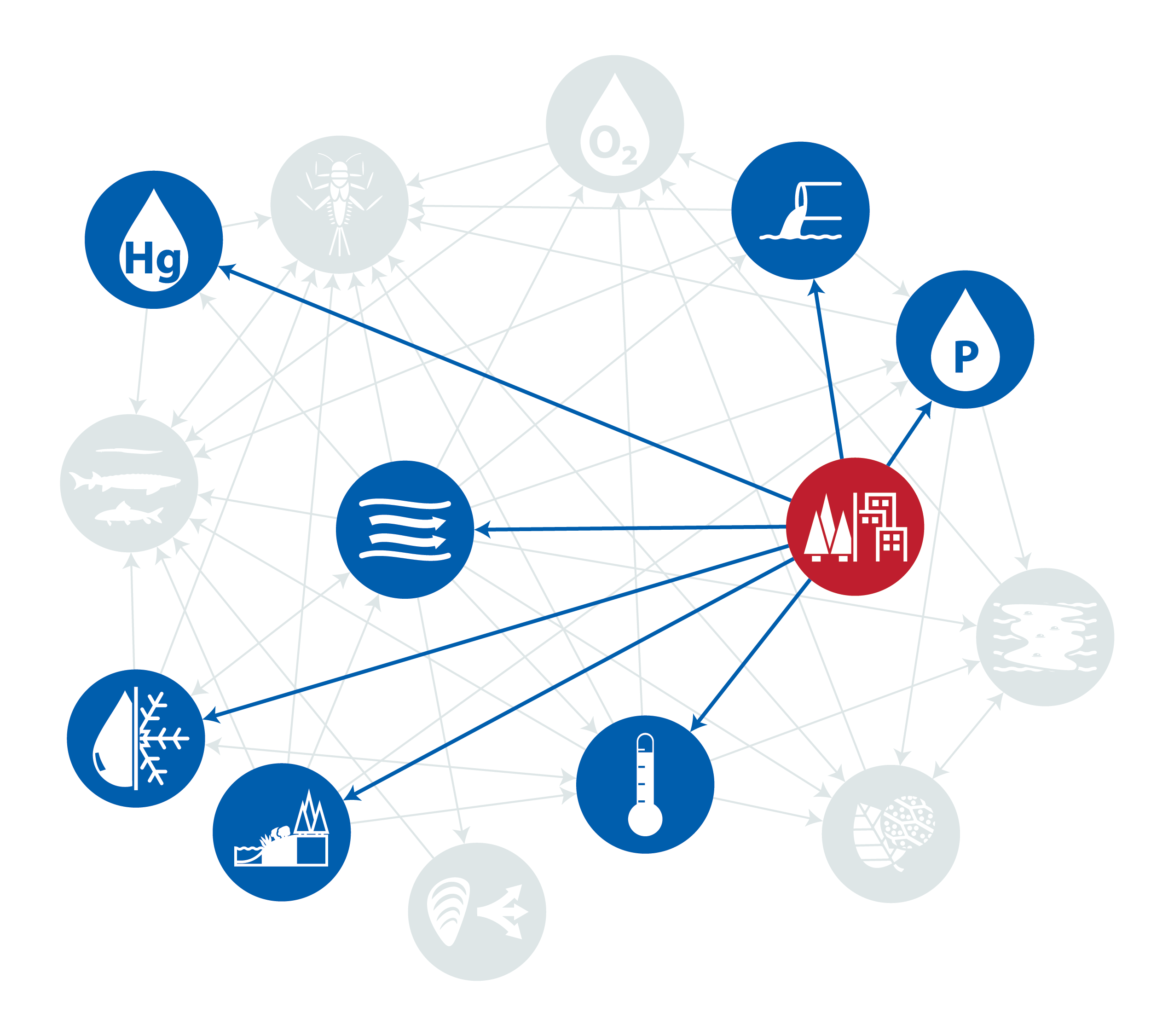
The introduction of impermeable surfaces (e.g. roads and roofs) associated with urbanization means less water is retained on the land, therefore increasing both the volume and momentum of water as it flows over the land. This increase in runoff volume has obvious consequences for flow such as rapid and drastic increases in river volume following heavy rainfall. More water flowing from the land into waterways also accelerates transporting sediment both into the rivers and within the streams as well, which can erode shorelines and impact riparian zones.
Changes in land use don’t just affect the amount of runoff, it can also affect the quality of nearby streams, lakes, and rivers. As the land changes and becomes more impermeable then pollutants, sediment, and nutrients can be transported more easily from surrounding areas into freshwater environments and adversely impacting the ecology. In agricultural areas, land uses and operations can alter runoff quantity, allowing fertilizers which contain an overabundance of nutrients to contribute an excess phosphorus in the river. In the winter months in most urbanised areas, road salt is added to sidewalks, driveways, bus stops, highways, and other high-traffic (pedestrian and vehicle) areas. While road salt plays an important role in public safety, overuse can result in dangerous increases in chloride levels which can have a lifelong impact on aquatic organisms.
Large, densely-populated urban centres can also have more direct impacts on water quality. Simply put, more people means more waste, and since replacing or updating existing sewage infrastructure is complicated and expensive, many urban areas still rely on outdated combined sewer systems, which collects domestic sewage, stormwater, and sometimes industrial wastewater into the same tunnel. Unfortunately, this means that heavy rainfall can often result in a volume that exceeds the infrastructures capacity, resulting in combined sewer overflows that introduce raw, untreated sewage into the river. It is for this reason that public beaches are often closed following heavy precipitation.
Reduction in natural land cover also has important implications for biodiversity. Deforestation and urban development destroy and fragment habitat for terrestrial and semi-aquatic animals. In the context of watershed health it’s important to monitor changes in land use, as it can often give context or clarity to changes in other important ecological factors. The land and the water are tightly connected, and changes to one will almost invariably result in changes to the other.
Relationships to other indicators:
Change in Land Use
Land use is a classification for all the various ways an area of land be used and includes agriculture, urban, roads, natural and harvested forests, wetlands and protected areas. Changes in land use have implications for both the quantity and quality of water introduced to the river through runoff and can help analyse changes in other indicators in proximity to where land use changes have occurred.
Algal Blooms
Algae are a group of single-celled and multicellular plant-like organisms. Algal growth contributes and supports the ecosystem in much the same way that plants do, through the production of oxygen and as a potential food source for smaller animals. However, when environmental conditions shift from their normal ranges, this can promote algal blooms, a rapid increase in population size of algae.
Water Temperature
With global temperatures on the rise, water temperature (particularly annual maximum temperatures) will be a crucially important indicator of watershed health moving forward. Water temperature is strongly correlated with a number of other important indicators of ecological status, and can often help to explain, give context to, or even predict changes in habitat quality.
Dissolved Oxygen
Dissolved oxygen (DO) is the concentration of free oxygen in the water column and comes from aquatic plants and algae through photosynthesis, and can also be transferred from the air at the surface of the water. DO is essential for all aquatic life and for the decomposition of organic waste. The amount of available oxygen in the water column is also affected by several abiotic factors including temperature, salinity, pressure and depth, wind, flow, and wave action.
Chlorophyll-a
Chlorophyll-a is used in oxygenic photosynthesis and is the predominant form of chlorophyll in green plants and algae. Measuring the presence of chlorophyll-a in an aquatic environment allows for a better understanding of the density and prevalence of algae which can have an impact on the concentration of dissolved oxygen or likeliness of algal blooms.
Total Phosphorus
Phosphorus is a fundamental building block of life. It has key structural roles in genetic material (eg. DNA) and cellular membranes, and is an active component of cellular energy production, storage, and transfer, meaning many necessary biochemical processes that all living organisms rely on (such as respiration, and nutrient absorption) can only happen if phosphorus is available.
Riparian Connectivity
Natural, vegetated riparian areas, the unique, transitional space between aquatic and terrestrial ecosystems, provide numerous benefits including nearshore habitat, filtering runoff, moderating local temperatures, and stabilizing shorelines. Measuring riparian connectivity can provide important information on the health of a watershed and a better understanding of the resilience to threats these areas have compared to shorelines that have been developed.
Combined Sewer Overflows
Everytime there is a Combined Sewer Overflow, sewage, along with stormwater is released into a waterbody introducing pollutants, pathogens and excess organic waste. Untreated or inadequately treated sewage poses health risks for people who use the water for recreational activities, such as swimming, paddling, etc. It also impacts aquatic ecosystems as the presence of organic matter, and its decomposition, decreases the amount of dissolved oxygen available.
Flow
How much water or volume of water present at a given time and how quickly it moves along the length of the river determines flow. Flow can provide context to a number of other indicators and as an important measure to factor when examining water chemistry or understanding impact of pollutants (for example, the same concentration of pollution will impact a river with low flow differently than one with high flow). Comparing flow within the same reach can help identify different trends and, when affected by barriers, can impact aquatic biota.
Benthic Invertebrates
Benthic invertebrates are the organisms found in soils, rocks and organic materials that make up stream, river, and lake beds. Pollution tolerance varies greatly between different species, so the relative abundances of pollution-sensitive and pollution-tolerant benthic invertebrate species is a good indicator of water quality and ecosystem health.
Invasive Species
Invasive species are non-native species that have been introduced to a habitat and are able to outcompete native species. Invasive species disrupt the established ecosystem which can result in a decrease in habitat quality and health.
Fish Richness
Fish richness is a measure of how many different species of fish are present in an ecosystem or habitat. Generally speaking, higher species richness is better, but some confounding factors include habitat type and the presence of invasive species (which can increase richness while threatening ecosystem health).
Water Mercury
Mercury is highly toxic, but naturally occurring concentrations of it are bound by plants and sediment and removed from the water column. However, human activity introduces excess mercury, resulting in free mercury in the water column. Water mercury is therefore a useful indication of human impact on the watershed.
Ice On/Off
Ice on is the date when a body of water is fully covered by ice, and ice off is the date when the ice disappears from the water surface. These measurements provide information about several environmental conditions, such as air temperature, water temperature, and flow.
Further resources:
