Posted: March 27, 2025
The Influence of Technology on Land Use and Land Cover Management

Technology has revolutionized how we track and manage land use and land cover, from manual surveys to sophisticated satellite imagery and GIS mapping. Understanding these advancements is key to making informed decisions about conservation, urban planning, and water resource management.
Understanding Land Use and Land Cover
Land use and land cover are often confused, but they have distinct meanings. Land use refers to how people utilize land, whether for agriculture, urban development, or conservation. Land cover, on the other hand, describes the physical features of the landscape, such as forests, wetlands, bare soil, or pavement. Understanding these concepts is crucial for decision-makers who may be managing competing demands, such as urban expansion and forest conservation. Land cover can also play an important role in watershed management given the influence of land cover on water quality. By monitoring the changes in land cover, we can protect ecosystems, manage erosion, and strengthen climate resilience.
Land use from early agricultural practices to modern urban planning has shaped economies, cultures, and ecosystems. As populations grow and industries expand, there are competing pressures on how land can be used to meet the needs of a community. Technology has provided new tools and techniques which are transforming how we monitor, plan, and utilize land.
Canada’s 2020 land cover map, which includes the Ottawa River watershed, is accessible through the Government of Canada’s open data portal. While these maps provide valuable insights, they often lack accuracy at local scales. Conservation authorities are working to refine and enhance these tools.
To learn more, you can watch A Shifting Landscape, a webinar featuring GIS expert Chris Czerwinski from the Rideau Valley Conservation Authority.
Early Methods of Tracking Land Use
Before modern technology, tracking land use was a slow and labour-intensive process. Governments, farmers, and city planners relied on hand-drawn maps, physical surveys, and local knowledge to make decisions. If someone needed to assess a piece of land, they had to physically visit it, take soil samples, and make educated guesses about its potential use.
Zoning decisions were often based on broad assumptions, and tracking land use changes was difficult. Planning new developments had to be done with the data available on paper and what data had been collected from the area. When mistakes were made, adjustments could take years to implement.
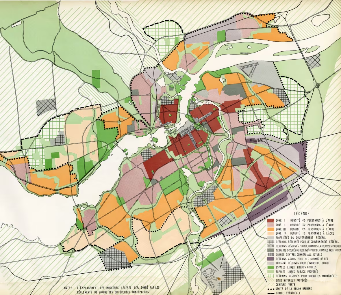
Gréber Plan – urban development plan for National Capital Region in 1950 (Source: CBC)
Aerial Photography and Satellite Imagery
Aerial photography, first used in the early 20th century, revolutionized land tracking by providing a bird’s-eye view of landscapes and making it much easier to map cities, farmlands, and forests. These photographs were often used to track changes in land use when large infrastructure projects were implemented, and now provide an important record of these historical changes.
The introduction of satellites provided this same data with more regularity, once again revolutionizing this work. By the 1970s, remote sensing technology allowed researchers to monitor land use on a global scale. Instead of relying solely on ground surveys and limited aerial photographs, experts could now analyze satellite images to track deforestation, urban expansion, and climate-related land changes in real time.
LiDAR: A Game-Changer in Land Mapping
One of the most advanced tools in land management today is Light Detection and Ranging (LiDAR) technology. Using laser pulses, LiDAR creates highly detailed 3D maps of landscapes, providing data at a finer scale than had ever been possible before. This technology is now widely used in conservation, archaeology, and infrastructure planning, and unlike traditional mapping methods, LiDAR can penetrate dense vegetation to reveal hidden terrain features, such as letting archaeologists uncover ancient structures or helping conservationists in tracking deforestation. In city planning, LiDAR provides precise topographical data, allowing for infrastructure development to be more responsive to local conditions and ideally have minimal environmental impact.
GIS: A New Era of Data-Driven Land Use Planning
If there’s one modern technology that has truly revolutionized land management, it’s Geographic Information Systems (GIS). GIS allows experts to store, analyze, and visualize spatial data in a way that was never possible before. Planners can overlay different datasets, such as soil quality, population density, and water resources, on a single map to make more informed decisions.
Want to know if a certain area is suitable for farming? GIS can tell you. Need to find the best route for a new highway? GIS has your back. By reducing reliance on guesswork, GIS enables precise and efficient land management strategies.
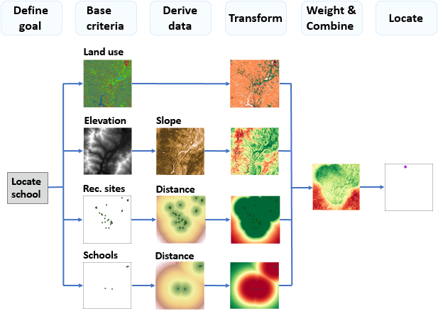
Process diagram for identifying the preferred location for a new school (Source: ESRI)
Technology and Water Protection
Water quality and quantity are directly influenced by land use, making effective monitoring essential for sustainability. Accurate data and proper tools are key to watershed protection, and technological advancements have greatly improved how we track and manage water resources. However, as GIS expert Chris Czerwinski highlighted in A Shifting Landscape, these tools require expertise, time-intensive verification, and significant processing power for large datasets. Updating and sharing this data remains a challenge due to file size and accessibility constraints.
Beyond identifying threats to water quality, modern technology also measures the impact of positive conservation efforts. Sustainable land use practices such as reforestation, riparian buffer zones, and responsible urban planning help protect waterways. With modern tools, experts can design, implement, and monitor these strategies in real time, ensuring clean and accessible water for future generations.
Looking Ahead
Advancements in technology have taken land tracking from paper maps to sophisticated satellite imagery and 3D modelling. While these tools enhance decision-making, challenges persist. In the Ottawa River watershed, data collection gaps remain, particularly between Ontario and Quebec. Additionally, some regions, including Renfrew County and Lake Temiskaming, lack dedicated conservation authorities to oversee land use monitoring.
To ensure effective land and water stewardship, a watershed-wide approach to data collection and monitoring is crucial. Ensuring that these technologies are used at a watershed scale to provide protections for habitat, conservation, and water quality would greatly benefit the Ottawa River and its tributaries.
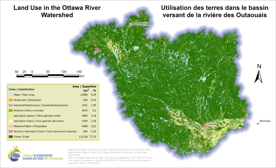
Land Use Land Cover Map of the Ottawa River Watershed