About Ottawa
Riverkeeper
What is a
Watershed?
What does a healthy
watershed look like?
Presenting
Sponsor
About Ottawa
Riverkeeper
Ottawa Riverkeeper, a charitable organisation, is a champion and collective voice for the Ottawa River watershed, providing leadership and inspiration to protect, promote and improve its ecological health and future.
Guided by a science-based approach, we provide clear information with the aim to engage the public and empower citizens and decision-makers, and inspire cooperative action focused toward ensuring clean, healthy, and accessible water for all people and species.
Learn more at ottawariverkeeper.ca!
What is a
Watershed?
A watershed, also known as a catchment or drainage basin, is simply all of the land and waterways that drain towards a single location. Here is another way to think about it: imagine a bathtub. As you add water to the bathtub, no matter where it falls within the bathtub it will eventually flow towards the drain. In a watershed, if water is poured onto the land (such as rainfall), it will eventually flow into a certain body of water (either directly, or via smaller tributaries). That area of land is then part of that body of water’s watershed.
Every body of water has a watershed, and can in turn be part of another watershed. For example, the area of land that drains into the Gatineau River makes up the Gatineau River watershed. The Gatineau River drains into the Ottawa River though, so all that land is also part of the Ottawa River watershed. The Gatineau River watershed is therefore considered a sub-watershed of the Ottawa River watershed. The Ottawa River watershed contains several large subwatersheds, and in turn is itself a subwatershed of the St Lawrence River watershed.
A watershed can have many different types of land cover. Forests, wetlands, waterbodies, cities, towns and other developed areas, and agricultural lands are all examples of land cover. The land cover present in a watershed can have an impact on the rivers within it by changing how quickly rainfall moves over the land. Plus, if there are pollutants, nutrients, or sediment, these might be transported to local streams and impact the river’s water quality. Everything within a watershed is connected; what happens in one area can have big impacts on the others.
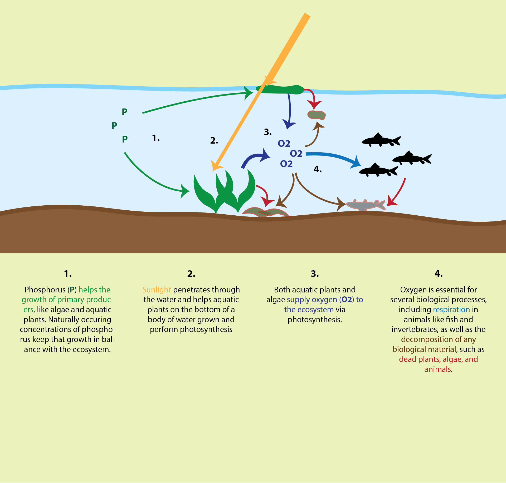
What does a healthy
watershed look like?
A healthy watershed is one where humans and nature live in balance. That means native species thrive, and their habitat remains intact, even alongside human habitation.
There are many interconnected factors that influence the ecological health of a river and its watershed. For example, for every watershed there will be normal, healthy ranges of water temperatures, flow volumes and rates, nutrient concentrations, as well as populations of native species. If conditions shift outside of their healthy ranges, or if there is pollution or the introduction of new species, that balance can be disrupted and change the health of the watershed. However, in a system as large and complex as the Ottawa River watershed, there is so much natural variation geographically, temporally, and seasonally, that determining whether the watershed as a whole is healthy or not is a difficult puzzle to solve. If there is pollution in the lower half of the river, but the areas upstream are still clean, is the whole watershed unhealthy? Does the presence of an invasive species in one area change the entire watershed as a whole? The answers to these questions, unfortunately, are not straightforward, but if we can detect and address issues quickly, we can protect other areas. By doing this, we can improve the overall health of the watershed.
This is why Ottawa Riverkeeper is working on a Watershed Health Assessment and Monitoring project. By working with experts, academic researchers, Algonquin communities, and volunteer citizen scientists, this ongoing project aims to collect and analyse data, and share what we learn with you as well as decision-makers. The data collection is focused on 14 indicators of aquatic ecosystem health, and collected throughout the watershed. By working together with lots of different groups and people, and by creating accessible educational tools like this discovery portal, we hope to inspire and empower citizens of the watershed to learn more about the health of the watershed and take actions to protect the incredible Ottawa River.
Presenting
Sponsor
Ottawa Riverkeeper’s Discovery Portal is presented by RBC.
Ottawa Riverkeeper would like to thank the generous support of RBC for making the Discovery Portal possible.
Additional funding for the Watershed Health Assessment and Monitoring initiative comes from:

Visit our website for more information about our partners and funding.
What effect does agriculture have on the watershed?
Agriculture and water are closely linked; water is needed to grow crops and raise livestock, but agricultural practices have a big influence on water quality. They pollute waterways over a large area, with no one specific location or source, which is different from pollution from something like sewer overflow, which adds pollution at a single point. On agricultural fields, water from rainfall, irrigation, or from melting snow moves across and through the ground, transporting pollutants into local waterways like lakes, wetlands, and rivers. For this reason, local agricultural practices and methods of cultivation can have a strong influence on water quality.
Nutrient levels in the water
One of the main impacts that agriculture has on water quality comes in the form of runoff. Pesticides sprayed on crops and waste produced by livestock can be harmful to aquatic life. Plus, fertiliser that isn’t absorbed by the plants and soil drains off into local waterways and adds an abundance of nutrients such as phosphorus and nitrogen, which can cause a detrimental imbalance in an aquatic ecosystem.
Soil that washes off of fields can enter local streams and cloud the water, blocking the sunlight from reaching aquatic plants. Soil particles can also carry chemicals like pesticides and fertilisers that have varied effects on the biology of nearby ecosystems. Fertilisers deliver nutrients like phosphorus, nitrogen, and potassium to plants that help them grow and produce plenty of food, but when they get into the water, the additional nutrients can encourage aquatic plants to grow or can also lead to algal blooms. Grazing by livestock can also loosen soil, which means more nutrients and chemicals may be carried into the water due to increased erosion.
The Role of Riparian Cover
Land use can directly impact local waterways and water quality, as described earlier. However, the shoreline (aka the riparian zone) has a lot of influence on how much runoff reaches freshwater ecosystems. Riparian cover, sometimes called a vegetated buffer, is the area along the river or lake that acts as the transition between aquatic and terrestrial environments. These areas can be rich in biodiversity and support a wide array of unique species, including ones that live on land, in the water, or both!.
Riparian cover can provide many benefits to rivers and waterbodies. The plants that grow there, particularly their root systems, can help control the volume of runoff, reduce sediments and other materials that reach the water, and help water to be absorbed into the ground. In addition to helping to control runoff, well-established riparian cover can help reduce erosion. These plants can also hang over the water, which helps regulate temperatures by creating shade and provides important habitat for some fish and other animals. The most effective riparian cover is wide and has a variety of different plant types. A wider shoreline is a bigger buffer between the land and the water and long grasses provide some benefits but not as much as a riparian area that also includes a mix of shrubs, flowers, ferns and trees.
Additional resources:
Related indicators of watershed health
Visit the Ottawa Riverkeeper Data Portal