About Ottawa
Riverkeeper
What is a
Watershed?
What does a healthy
watershed look like?
Presenting
Sponsor
About Ottawa
Riverkeeper
Ottawa Riverkeeper, a charitable organisation, is a champion and collective voice for the Ottawa River watershed, providing leadership and inspiration to protect, promote and improve its ecological health and future.
Guided by a science-based approach, we provide clear information with the aim to engage the public and empower citizens and decision-makers, and inspire cooperative action focused toward ensuring clean, healthy, and accessible water for all people and species.
Learn more at ottawariverkeeper.ca!
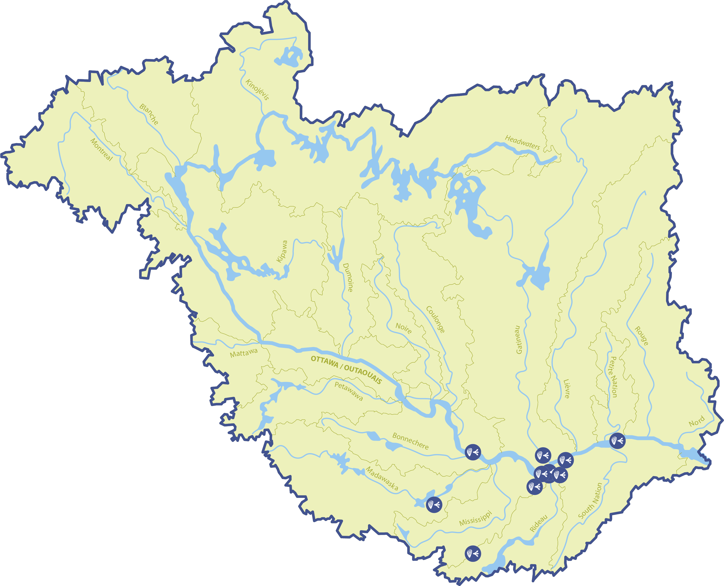
What is a
Watershed?
A watershed, also known as a catchment or drainage basin, is simply all of the land and waterways that drain towards a single location. Here is another way to think about it: imagine a bathtub. As you add water to the bathtub, no matter where it falls within the bathtub it will eventually flow towards the drain. In a watershed, if water is poured onto the land (such as rainfall), it will eventually flow into a certain body of water (either directly, or via smaller tributaries). That area of land is then part of that body of water’s watershed.
Every body of water has a watershed, and can in turn be part of another watershed. For example, the area of land that drains into the Gatineau River makes up the Gatineau River watershed. The Gatineau River drains into the Ottawa River though, so all that land is also part of the Ottawa River watershed. The Gatineau River watershed is therefore considered a sub-watershed of the Ottawa River watershed. The Ottawa River watershed contains several large subwatersheds, and in turn is itself a subwatershed of the St Lawrence River watershed.
A watershed can have many different types of land cover. Forests, wetlands, waterbodies, cities, towns and other developed areas, and agricultural lands are all examples of land cover. The land cover present in a watershed can have an impact on the rivers within it by changing how quickly rainfall moves over the land. Plus, if there are pollutants, nutrients, or sediment, these might be transported to local streams and impact the river’s water quality. Everything within a watershed is connected; what happens in one area can have big impacts on the others.
What does a healthy
watershed look like?
A healthy watershed is one where humans and nature live in balance. That means native species thrive, and their habitat remains intact, even alongside human habitation.
There are many interconnected factors that influence the ecological health of a river and its watershed. For example, for every watershed there will be normal, healthy ranges of water temperatures, flow volumes and rates, nutrient concentrations, as well as populations of native species. If conditions shift outside of their healthy ranges, or if there is pollution or the introduction of new species, that balance can be disrupted and change the health of the watershed. However, in a system as large and complex as the Ottawa River watershed, there is so much natural variation geographically, temporally, and seasonally, that determining whether the watershed as a whole is healthy or not is a difficult puzzle to solve. If there is pollution in the lower half of the river, but the areas upstream are still clean, is the whole watershed unhealthy? Does the presence of an invasive species in one area change the entire watershed as a whole? The answers to these questions, unfortunately, are not straightforward, but if we can detect and address issues quickly, we can protect other areas. By doing this, we can improve the overall health of the watershed.
This is why Ottawa Riverkeeper is working on a Watershed Health Assessment and Monitoring project. By working with experts, academic researchers, Algonquin communities, and volunteer citizen scientists, this ongoing project aims to collect and analyse data, and share what we learn with you as well as decision-makers. The data collection is focused on 14 indicators of aquatic ecosystem health, and collected throughout the watershed. By working together with lots of different groups and people, and by creating accessible educational tools like this discovery portal, we hope to inspire and empower citizens of the watershed to learn more about the health of the watershed and take actions to protect the incredible Ottawa River.
Presenting
Sponsor
Ottawa Riverkeeper’s Discovery Portal is presented by RBC.
Ottawa Riverkeeper would like to thank the generous support of RBC for making the Discovery Portal possible.
Additional funding for the Watershed Health Assessment and Monitoring initiative comes from:

Visit our website for more information about our partners and funding.
Are invasive species present in the Ottawa River watershed?
In the last 50 years, the number of invasive species in the Ottawa River watershed has increased significantly. The ways that invasive species can affect an environment, as well as the severity of those effects can be very different depending on the species and the habitat. While some may be able to fill a role in the ecosystem that native species don’t already fill, resulting in minimal impacts, others have been known to outcompete native species so much that they deplete resources and completely reshape entire ecosystems.
Most invasive species are introduced because of human activity. Releasing pets, planting non-native plants in home gardens, and transporting boats between water bodies without proper washing in between are common ways that invasive species are introduced and spread. Climate change can also play a role, because it may change habitats in such a way that certain species have an advantage and can expand their ranges into areas that they used to not be able to get to.
Explore the resources below to learn more about invasive species in the Ottawa River watershed, and ways you can help monitor and stop the spread!
Jérôme Marty, Limnologist (someone who studies freshwater environments) and member of the Watershed Health Committee, discusses why invasive species are a concern, and the impact one species in particular, the infamous zebra mussel, has on the Ottawa River watershed.
Invasive Species Map
Each point represents a location where invasive species were spotted and Ottawa Riverkeeper was notified directly. Members of our community have also been submitting their sightings of invasive species to other species monitoring programs like iNaturalist and Water Rangers for years. Check out the maps below to see those observations.
Here are some of the invasive species in the Ottawa River watershed
Zebra Mussel
WHAT IT LOOKS LIKE:
- Small; between 2 cm – 2.5 cm (can reach up to 4 cm)
- Shell triangular or “D” shaped
- Black or brown in colour with white/yellow zig-zag pattern; colour patterns may vary
WHERE IT’S FOUND:
- Lakes, rivers, ponds with little current/wave action
- Larvae are free-floating, while adults settle on hard surfaces such as wood, rocks, docks, cement and plants
- *Due to the low calcium content of the water, zebra mussels are largely absent from the mainstem of the Ottawa River
HOW IT’S SPREAD:
- Adults and larvae (microscopic) can be transported in boat bilge water
- Adults may also attach to hard surfaces such as boat hulls and motors, and on other watercraft and equipment
- Adults can survive out of water for 5 days (up to 22 days when air is cool (15ºC) and humid
IMPACTS:
- Form large dense colonies that can outcompete native freshwater mussels species for food and resources
- May attach to native mussel species threatening their ability to feed, move and reproduce
- Linked to increases in harmful algal blooms
- Part of the Round Goby’s diet, thus facilitating their colonization
Purple Loosestrife
WHAT IT LOOKS LIKE:
- Plants can grow quite tall – between 1.5 m to 2.4 m
- Stems woody and square with opposite leaves 3 – 10 cm long with smooth edges
- Long flower spikes with 5 – 7 individual pink/purple flowers roughly 1 cm
SIMILAR SPECIES:
- Swamp loosestrife, Native winged loosestrife, Pickerel-weed
WHERE IT’S FOUND:
- Shoreline of rivers and streams, floodplains, wetlands, marshes, ditches, and fields
- Abundant throughout southern parts of watershed
HOW IT’S SPREAD:
- Used as an ornamental plant which, if planted too close to shoreline, may spread to other areas via loose plant material during flooding or heavy rain events
- Plant material (e.g., root buds, seeds) may also be spread by boats and other watercraft or aquatic equipment
IMPACTS:
- May outcompete native plant species for nutrients, resources and space, reducing overall biodiversity
Eurasian Milfoil
WHAT IT LOOKS LIKE:
- Grows under surface of water
- Leaves are green and feather-like, and circle the stem in groups of four or five
- Leaves have 12 or more thread-like segments
- Tiny, reddish flowers grow on spikes 5 – 20 cm long that rise above the water
SIMILAR SPECIES:
- Native water milfoils and coontails
WHERE IT’S FOUND:
- More common in shallow (1 – 3m deep) waters of lakes, rivers, streams, ponds, but can also occur in waters at depths up to 10 m
HOW IT’S SPREAD:
- Plant material (e.g., small fragments, seeds) are transported on boats or other equipment (e.g., fishing gear, boat trailers, scuba gear, etc.)
IMPACTS:
- Forms dense stands and entangled branches which can cover large areas of water, suppressing native vegetation
- May also hybridize with native milfoils resulting in more aggressive invasive species
European Frog-bit
WHAT IT LOOKS LIKE:
- Free floating or rooted with roots up to 50 cm long
- Produces a single flower with three white petals and yellow center
- Leaves are round or heart shaped and 2.5 – 5 cm wide
- Leaf bottom is purple with a spongy coating along the middle vein
SIMILAR SPECIES:
- North American frog-bit, Native water shield
WHERE IT’S FOUND:
- Slow moving waters of ponds, rivers, ditches, and sheltered inlets
- Originally introduced at the Central Experimental Farm in Ottawa, European frog-bit then spread to the Rideau Canal and connecting waterways
HOW IT’S SPREAD:
- Plant material (e.g., small fragments, seeds) are transported on boats or other equipment (e.g., fishing gear, boat trailers, scuba gear, etc.)
IMPACTS:
- Can form dense, floating mats, restricting water flow, and depleting oxygen levels and blocking access to sunlight for submerged plant and animal species
Round Goby
WHAT IT LOOKS LIKE:
- Body brownish or olive in colour, with dark brown spots, except in reproducing males who are almost completely black
- Prominent black spot on dorsal fin
- Fused scallop-shaped pelvic fin
- Nostril tubes do not reach the upper lip
- Fully scaled body
WHERE IT’S FOUND:
- In lakes, and middle and lower reaches of rivers, both nearshore and in deep waters
- Prefer water bodies with cobble, gravel and sandy substrates
- Observed in Rideau Canal
HOW IT’S SPREAD:
- In boat ballast water
- Unintentionally introduced as live bait *It is illegal to possess Round Goby in Ontario
IMPACTS:
- Outcompetes and/or preys upon native fish species and game fish stocks
Rusty Crayfish
WHAT IT LOOKS LIKE:
- Large; adults can reach 7.5 to 13 cm from rostrum (snout) to tail
- Rusty patches on each side of shell
- Grey-green to red-brown claws with black bands near the tips
- Claws have an oval cap when closed
- Rostrum is smooth, pinched and distinctly concave
SIMILAR SPECIES:
- Native crayfish species
WHERE IT’S FOUND:
- Wetlands, ponds, rivers, lakes
- Prefers areas with rocks and logs and clay silt and gravel bottoms
HOW IT’S SPREAD:
- Escape or release of rusty crawfish used as bait
IMPACTS:
- May outcompete native crayfish species for food, resources, and space, reducing overall biodiversity
Japanese Knotweed
WHAT IT LOOKS LIKE:
- Large, capable of reaching 1 – 3 meters high
- Round, bamboo-like stems that are reddish-purple in colour
- Large ( 7 – 15 cm long, 5 – 12 cm wide), dark green, teardrop shaped leaves with pointed tips
- Produces flower stalks with many tiny white/pale green flowers
- Small white fruit with wings to help them disperse
WHERE IT’S FOUND:
- Wetlands and near shorelines of rivers, lakes, streams, and in roadside ditches
HOW IT’S SPREAD:
- Used as an ornamental plant which, if planted too close to shoreline, may spread to other areas via plant material during flooding or heavy rain events
- Plant material (e.g., root fragments) may also be spread by boats and other watercraft or aquatic equipment
IMPACTS:
- May outcompete native plant species for nutrients, resources and space, reducing overall biodiversity
Invasive Phragmites
WHAT IT LOOKS LIKE:
- Grows in stands that can be extremely dense
- Can reach heights of up to 5 metres
- Stems that are tan-beige in colour with blue-green leaves
- Large, dense seedheads
SIMILAR SPECIES:
- Native phragmites (tend to form less dense stands; stems are reddish-brown with yellow-green leaves and smaller seedheads)
WHERE IT’S FOUND:
- In shallow waters of wetlands; along banks and shores of rivers, streams and lakes; and wet fields and ditches
HOW IT’S SPREAD:
- Used as an ornamental plant which, if planted too close to shoreline, may spread to other areas via plant material during flooding or heavy rain events
- Plant material (e.g., fragments, seeds) may also be spread by boats and other watercraft or aquatic equipment
IMPACTS:
- May outcompete native plant species for nutrients, resources and space, reducing overall biodiversity
European Water Chestnut
WHAT IT LOOKS LIKE:
- Floating leaves, green and triangle/spade-shaped with sharply toothed edges
- Leaves form a densely crowded rosette up to 30 cm across
- Produces small white flowers (less than 1 cm long), with 4 petals
- Produces a hard “woody” nut (seed), 3-4 cm wide with sharp barbed spines
WHERE IT’S FOUND:
- Lakes, rivers, streams and ponds, in waters 2 – 4 m deep
HOW IT’S SPREAD:
- Used as an ornamental plant which, if planted too close to shoreline, may spread to other areas via plant material during flooding or heavy rain events
- Plant material (e.g., fruits, seeds) may also be spread by boats and other watercraft or aquatic equipment
IMPACTS:
- Can form dense, floating mats reducing amount of light submerged species receive
Yellow Iris
WHAT IT LOOKS LIKE:
- Plants grow between 30 cm – 1 m tall
- Yellow flowers with three drooping sepals (resemble large petals) surrounding three smaller upright petals, grow in groups of 2 to 10
- Leaves are flattened, 2 – 3 cm wide, and up to 1 m long, fanning out from the base
- Blooms between April and July
WHERE IT’S FOUND:
- Wetlands and shallow waters of streams, rivers, lakes, and ponds
HOW IT’S SPREAD:
- Often used as an ornamental plant which, if planted too close to shoreline, may spread to other areas via plant material during flooding or heavy rain events
- Plant material may also be spread by boats and other equipment
IMPACTS:
- Forms dense stands that can outcompete native plant species for nutrients, resources and space, reducing overall biodiversity
- May also convert a wet habitat into a drier one
- Rhizomes (root projections) may cause poisoning in animals if ingested, or skin blisters in humans if plant juices make contact with skin
Water Lettuce
WHAT IT LOOKS LIKE:
- Free floating aquatic plant; can form large and dense floating mats
- Several leaves forming a rosette
- Leaves are light green with thick, parallel ridges, and short white hairs; rounded at top and narrow towards base (2 – 20 cm in length)
- May have small white/pale green flowers on a small stalk
- Many feathery roots 50 – 80 cm long hang below rosette
WHERE IT’S FOUND:
- Found in slow moving waters in rivers, lakes, streams, ponds, and ditches
- Generally found when temperatures are warmer
- Reported sightings in ponds connected to the Rideau Canal in Ottawa
HOW IT’S SPREAD:
Plant material (e.g., rosettes, leaves, seeds) are transported on boats or other equipment (e.g., fishing gear, boat trailers, scuba gear, etc.)
IMPACTS:
Can form dense, floating mats, restricting water flow, and depleting oxygen levels and blocking access to sunlight for submerged plant and animal species
Yellow Floating Heart
WHAT IT LOOKS LIKE:
- Long, branched stems reaching up to 1 m or more, located below the surface of the water
- Circular or heart shaped leaves 3-10 cm in length
- Bright yellow flowers with 5 petals; petals are fringed or ruffled along edge
- Produce seed capsules with numerous flat, oval seeds
WHERE IT’S FOUND:
- Slow moving waters of rivers, lakes, ponds, and canals
- Can also grow on damp mud
- Found in ponds connected to the Rideau Canal
HOW IT’S SPREAD:
- Used as an ornamental plant which, if planted too close to shoreline, may spread to other areas via plant material during flooding or heavy rain events
- Plant material (e.g., fruits, seeds) may also be spread by boats and other watercraft or aquatic equipment
IMPACTS:
- Can form dense, floating mats, depleting oxygen levels and blocking access to sunlight for submerged plant and animal species
Flowering Rush
WHAT IT LOOKS LIKE:
- Can grow up to 1 m in height
- Flowers grow in umbrella shaped clusters and each individual flower has 3 whitish-pink petals
- Green stems that resemble bulrushes but are triangular in cross-section
WHERE IT’S FOUND:
- Found along shores or in shallow waters (up to 2 m deep) of lakes, rivers, ponds, streams, wetlands, ditches
HOW IT’S SPREAD:
- Often used as an ornamental plant which, if planted too close to shoreline, may spread to other areas via plant material during flooding or heavy rain events
- Plant material may also be spread by boats and other equipment
IMPACTS:
- May outcompete native plant species for nutrients, resources and space, reducing overall biodiversity
Himalayan Balsam
WHAT IT LOOKS LIKE:
- Stems are hollow and smooth and often purple-red
- Can grown 1 to 3 metres tall
- Flowers have 5 pink, white or purple petals
SIMILAR SPECIES:
- Jewelweed (has orange flowers)
- WHERE IT’S FOUND:
- Wetlands and near shorelines of rivers, lakes, streams, and in roadside ditches
HOW IT’S SPREAD:
- Used as an ornamental plant which, if planted too close to shoreline, may spread to other areas via plant material during flooding or heavy rain events
- Plant material (e.g., fruits, seeds) may also be spread by boats and other watercraft or aquatic equipment
IMPACTS:
- May outcompete native plant species for nutrients, resources and space, reducing overall biodiversity
- Produces a lot of nectar to attract pollinating insects, potentially resulting in reduced pollination for native species
Spiny Waterflea
WHAT IT LOOKS LIKE:
- Very small, total length of 1.5 cm (60% of which is their tail)
- Long, straight tail with 1 to 3 barbs and a pointed end; red stripe runs along half the length of tail
- Ballon-like egg pouch (located on back, above tail)
- May be orange, green or blue in colour
SIMILAR SPECIES:
- Fishhook waterflea (another invasive species, however unreported in watershed to date)
WHERE IT’S FOUND:
- In rivers and lakes
- Present in Lake Temiskaming with populations also reported throughout the Ottawa River
- Often found in clumps comprised of many individuals
HOW IT’S SPREAD:
- Transported in boat bilge water and in bait buckets
- May also attach to hard surfaces such as boat hulls and motors, and on angling equipment
IMPACTS:
- The introduction of a small number of Spiny Waterflea can lead to very large populations
- Can result in an on average 30 – 40% decline of native zooplankton population leading to a reduction of food available to small and juvenile fish
May also impact angling activities with their tail spines catching on fishing lines making it difficult to reel them in, as well as clogging nets
iNaturalist map of invasive species sightings
In addition to receiving reports of invasive species sent straight to us through our observation submission form, we keep an eye on reports of invasive species throughout the watershed that were submitted to other initiatives like iNaturalist (this map) and Water Rangers.
Jellyfish in the Ottawa River watershed?
The Craspedacusta sowerbii is an invasive freshwater jellyfish that originates from China. It was first recorded in Quebec in 1938 and has since been recorded in lakes in Ontario and New Brunswick and, in recent years, in British Columbia and Manitoba. While this translucent jellyfish becomes no larger than 2.5cm, its proliferation in Canadian lakes can be attributed to increasing nutrients (from changes in land use) and warmer water temperatures linked to climate change.
How you can help
Report an invasive species sighting
Additional resources:
Related indicators of watershed health
Visit the Ottawa Riverkeeper Data Portal