About Ottawa
Riverkeeper
What is a
Watershed?
What does a healthy
watershed look like?
Presenting
Sponsor
About Ottawa
Riverkeeper
Ottawa Riverkeeper, a charitable organisation, is a champion and collective voice for the Ottawa River watershed, providing leadership and inspiration to protect, promote and improve its ecological health and future.
Guided by a science-based approach, we provide clear information with the aim to engage the public and empower citizens and decision-makers, and inspire cooperative action focused toward ensuring clean, healthy, and accessible water for all people and species.
Learn more at ottawariverkeeper.ca!
What is a
Watershed?
A watershed, also known as a catchment or drainage basin, is simply all of the land and waterways that drain towards a single location. Here is another way to think about it: imagine a bathtub. As you add water to the bathtub, no matter where it falls within the bathtub it will eventually flow towards the drain. In a watershed, if water is poured onto the land (such as rainfall), it will eventually flow into a certain body of water (either directly, or via smaller tributaries). That area of land is then part of that body of water’s watershed.
Every body of water has a watershed, and can in turn be part of another watershed. For example, the area of land that drains into the Gatineau River makes up the Gatineau River watershed. The Gatineau River drains into the Ottawa River though, so all that land is also part of the Ottawa River watershed. The Gatineau River watershed is therefore considered a sub-watershed of the Ottawa River watershed. The Ottawa River watershed contains several large subwatersheds, and in turn is itself a subwatershed of the St Lawrence River watershed.
A watershed can have many different types of land cover. Forests, wetlands, waterbodies, cities, towns and other developed areas, and agricultural lands are all examples of land cover. The land cover present in a watershed can have an impact on the rivers within it by changing how quickly rainfall moves over the land. Plus, if there are pollutants, nutrients, or sediment, these might be transported to local streams and impact the river’s water quality. Everything within a watershed is connected; what happens in one area can have big impacts on the others.
What does a healthy
watershed look like?
A healthy watershed is one where humans and nature live in balance. That means native species thrive, and their habitat remains intact, even alongside human habitation.
There are many interconnected factors that influence the ecological health of a river and its watershed. For example, for every watershed there will be normal, healthy ranges of water temperatures, flow volumes and rates, nutrient concentrations, as well as populations of native species. If conditions shift outside of their healthy ranges, or if there is pollution or the introduction of new species, that balance can be disrupted and change the health of the watershed. However, in a system as large and complex as the Ottawa River watershed, there is so much natural variation geographically, temporally, and seasonally, that determining whether the watershed as a whole is healthy or not is a difficult puzzle to solve. If there is pollution in the lower half of the river, but the areas upstream are still clean, is the whole watershed unhealthy? Does the presence of an invasive species in one area change the entire watershed as a whole? The answers to these questions, unfortunately, are not straightforward, but if we can detect and address issues quickly, we can protect other areas. By doing this, we can improve the overall health of the watershed.
This is why Ottawa Riverkeeper is working on a Watershed Health Assessment and Monitoring project. By working with experts, academic researchers, Algonquin communities, and volunteer citizen scientists, this ongoing project aims to collect and analyse data, and share what we learn with you as well as decision-makers. The data collection is focused on 14 indicators of aquatic ecosystem health, and collected throughout the watershed. By working together with lots of different groups and people, and by creating accessible educational tools like this discovery portal, we hope to inspire and empower citizens of the watershed to learn more about the health of the watershed and take actions to protect the incredible Ottawa River.
Presenting
Sponsor
Ottawa Riverkeeper’s Discovery Portal is presented by RBC.
Ottawa Riverkeeper would like to thank the generous support of RBC for making the Discovery Portal possible.
Additional funding for the Watershed Health Assessment and Monitoring initiative comes from:

Visit our website for more information about our partners and funding.
Will climate change impact the Ottawa River watershed?
As the impacts of climate change due to human activities become felt more and more, scientists are trying to track its effects around the world. The Ottawa River watershed is also experiencing climate change, such as more dramatic and sporadic weather events and a shift away from previously predictable seasonal changes. These effects will not only impact the humans that live within the watershed, but the other species that rely on certain temperature ranges and freeze-thaw cycles to survive.
Ice on/ice off
Ice on is the date when a body of water becomes completely covered by a layer of ice, and Ice off is the date when that body of water becomes completely clear of ice. Ice on and ice off tracks the start and end dates of when water bodies are covered by ice. Changes to when and for how long ice stays on a body of water can shed light on the overall health of the watershed. The timing for Ice on/ice off cycles are closely linked to changes in both air and water temperature. Changes in winter ice influences many different different environmental conditions in the river. Ice can prevent access to areas of the river and different habitats. Ice cover can also affect the amount of light that gets through to deeper water and the species that live there, as well as influence water temperature and flow.
The cycle of ice coverage on rivers and lakes serves as an important biological cue for many species. When ice forms in the winter, the waterbody beneath the ice is able to retain some of its heat over the course of the season. That means the water doesn’t get as cold as it would if the ice was not present, which is important for species that live in these waters over the winter months. Ice on also signals some species to begin hibernation, or hibernation-like behaviours. At the other end of the season, ice melting in the spring serves as a signal for the beginning of spawning and/or major foraging seasons. Changes in the cycle of ice coverage can affect the growth and survival of plants and animals in the water.
The ice on and off cycle also influences the amounts of sediment and nutrients that can get into the water. During the winter, sediment and organic material from along the shore or riverbed attaches to ice as it forms. Then, when temperatures rise and the ice begins to melt, this material, combined with runoff from melting snow and rainfall, begins to move through the river system, increasing flow rates and volumes, during what is known as the Spring Freshet. More water flowing over the surrounding land and higher flow rates means sediment is carried to different parts of the river. When this happens, nutrients like carbon and phosphorus are also brought to new areas, contributing to the growth of phytoplankton and other small organisms that serve as the base of the food chain.
Water Temperature
Water temperature varies diurnally (between day and night), seasonally, and yearly. Often there are differences in the highest and lowest temperatures from year to year. These changes can be influenced by many different factors, like the size of the river system, groundwater input, and if the stream is shaded by tall trees and vegetation. However, water temperature is most significantly influenced by air temperature, which is one of the major reasons why water temperatures are much cooler during the night and in the winter.
There is strong evidence that the climate in the watershed has been warming. This means maximum temperatures in the mainstem of the Ottawa River and its tributaries and lakes will be higher. This will affect river habitats in many ways. Warmer water temperatures can result in less oxygen in the water, lower pH (more acidic), increased conductivity and more. For each of those factors, fish and invertebrates have specific ranges that they can tolerate, so any changes can be stressful or even fatal if the animals are unable to adapt or escape.
Flooding and low levels
The amount of water flowing in a stream varies naturally throughout the year. In the Ottawa River watershed, since the snow that had piled up in the winter is still melting at around the same time as the heavy rains that typically occur each April and May, rivers experience high flow throughout the spring. Given the size of the watershed there is quite a bit of variability depending on where you are.
The tributaries are impacted by events in their subwatersheds which results in spring flows that are shorter in duration than the spring flows or freshet that the Ottawa River experiences. Higher water levels in the Ottawa River can last for much longer periods of time because each tributary contributes water to the mainstem of the river. This happens one after the other as the temperatures gradually warm from the lower part of the watershed to the northern reaches over a number of days and weeks. A second high water season occurs later in the fall, when seasonal rainfall is high.The ground has absorbed as much water as it can hold and becomes saturated, and the vegetation (trees, shrubs, grasses) have stopped needing as much water in preparation for the winter so the water is not absorbed as quickly, or possibly not at all. This peak in the fall, while noticeable, is not as significant as the spring flooding. Maximum water levels tend to get the most attention, because flooding impacts many people and businesses, but minimums are also ecologically relevant. Low water occurs seasonally at the end of summer, with the lowest water typically occurring in late August to early September.
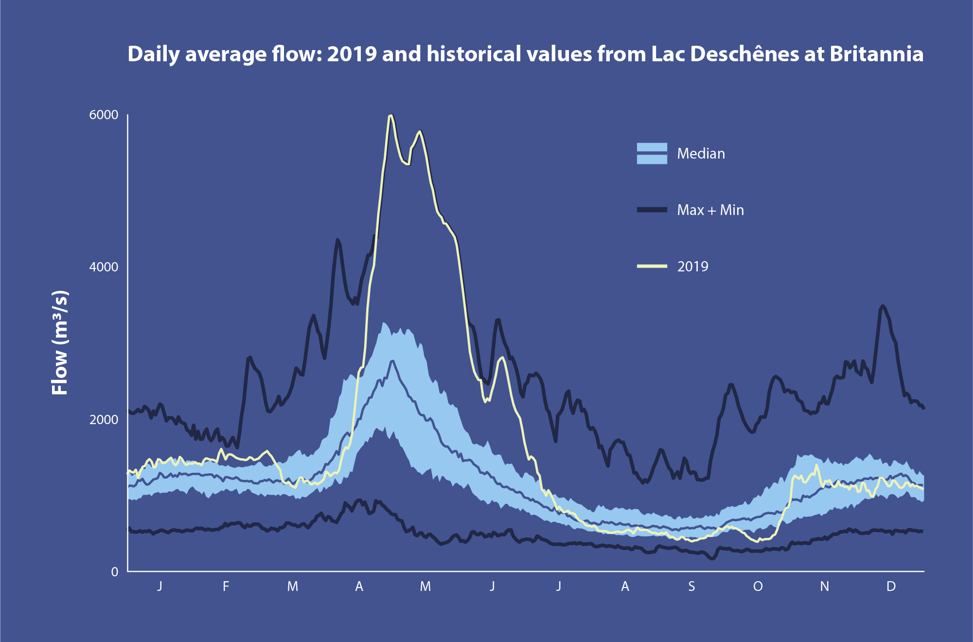
Understanding the timing and duration of high and low water levels are one way to track changes in the watershed. Not only are water levels of interest when trying to understand how climate change is impacting the watershed but also the timing of seasonal extremes. For example, while many people will remember the historic flooding that occurred throughout a large portion of the Ottawa River for an extended period of time in 2019, there was also a period of near record breaking low water later in the summer that same year. This variation in extremes need to be tracked and understood to fully capture the impact of climate change.